Part 2: The Emergence of Form-Based Codes
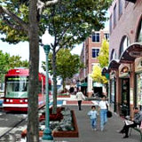
The concepts of “urban form” and “the public realm,” central to form-based codes, are absent from the conventional zoning vocabulary. A look at key differences between FBCs and traditional zoning.


How to best deal with cars, trucks, and the street network has long been a major preoccupation of planners — as the many articles we've published on this attest!
Continue to older articles & posts — or return to newer ones — where you see the green buttons at the bottom of the page.
The concepts of “urban form” and “the public realm,” central to form-based codes, are absent from the conventional zoning vocabulary. A look at key differences between FBCs and traditional zoning.
Wider vs narrower residential streets & safety: to help you decide what is best for your neighborhoods and community, a look at some of the data and issues in the debate.
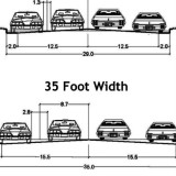
Many communities are now debating decreasing neighborhood street width. Planning commissioners need to understand the pros and cons of this debate. How narrow is too narrow — and how wide is too wide?
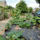
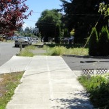
What can residents do with that narrow strip of grass or plants and sometimes also trees usually located between the curb and the sidewalk. In Portland, homeowners have come up with some creative answers.
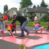
What do street intersections have to do with strong neighborhoods and empowered citizens? Aren’t intersections just for dividing up blocks, and getting traffic through? Take a look at a program that’s turned intersections on their head.
Comparing two neighborhoods: the older, streetcar era neighborhood (discussed in the last two posts) with a newer post World War II area with a low-density, auto-centric, pattern of development.
A look at how Portland has gone beyond “Walk Score” in using a detailed rating system to evaluate neighborhood “walkability” — and why one older neighborhood fares quite well.

Brunswick, Maine has a wonderful downtown. The sidewalks are perfect for strolling and window shopping. Downtown is just about ideal. Except for one thing: those human squirrels you see scurrying across Maine Street.

One of the key themes I heard during sessions at the Association of Metropolitan Planning Organizations conference was the importance of better connecting pedestrians to nearby shopping and to transit corridors. That means focusing on one of the most basic components of a community’s transportation network: sidewalks.
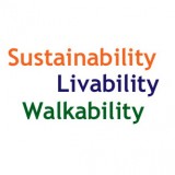
During the AMPO (Association of Metropolitan Planning Organizations) conference the past two days, the three words I think I heard most often were Sustainability; Livability; and Walkability. What’s more all three of these were often tied in to another phrase: economic competitiveness.
Hannah Twaddell reports on a recent article by Rich Kuzmyak and Jennifer Dill on what to take into account in appealing to bicyclists and walkers.
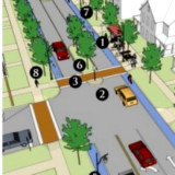
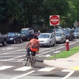
A growing number of communities are developing “complete streets” policies and programs. What’s behind this new approach to local transportation planning?

PCJ Editor Wayne Senville asks the authors of our Fall feature article some follow-up questions about their article.