Editor’s Note: In responses to a questionnaire we sent out last Spring, “Low Impact Development” (also often referred to as low impact design) was at the top of the list of subjects that readers want to know more about. In this series, Lisa and Jim will explain the basics of LID: how it works; why your community may need it; how LID costs compare to conventional stormwater management; and the types of ordinances that have worked to implement LID in communities around the country.
Part I: What is LID?
Low Impact Design is the terminology used in the United States primarily to designate a land planning and engineering design approach to stormwater management which emphasizes conservation and the use of on-site natural features to protect water quality. (Later in this series, we’ll make the case for a broader definition of LID.)
This definition is important because conventional development treats stormwater as a waste product that is conveyed offsite and disposed of. Let’s look at the definition of stormwater and at our history of stormwater management to help establish the context for LID.
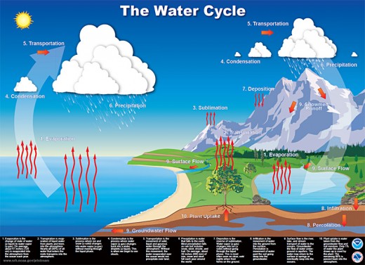
Stormwater: a term used to identify water that originates during precipitation events. Simply put, it is rainfall that contacts the earth’s surface. Stormwater is a natural part of the hydrologic cycle, which you may recall from your middle school earth science class. Water vapor collects in the atmosphere, which becomes clouds, which becomes rain, which recharges groundwater and surface water, which evaporates to become water vapor … and this is a continuous dynamic cycle.

This simplistic explanation leaves out the details of how rainfall recharges both groundwater and surface water, a dynamic balance that depends on many variables at a given location, including the characteristics of the natural and built environments in the watershed.
Generally speaking, in an undeveloped watershed, about half of the rainwater infiltrates the land and becomes groundwater, while the other half travels via overland flow to join streams and rivers. However, the exact ratio of surface and groundwater recharge by rainfall varies according to climate, soils, slope, ground cover, and other specific conditions in the watershed.
When human settlements began significantly altering land cover patterns, the behavior of rainfall on the land surface was changed. As the built environment increasingly favored impermeable surfaces (rooftops, paved roads, and other urban “hardscapes”), the disposition of rainfall changed, causing more of the rain that fell to run off the land and less to infiltrate to recharge groundwater.
As we continued to develop the land surface, we caused greater volumes of rainfall to run off at the expense of groundwater infiltration. Over time, rainfall runoff volumes in urban areas became so significant that we began treating it like a waste product to be conveyed away from developed areas as quickly as possible.
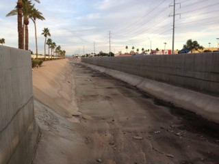
Open concrete channels are a common part of our stormwater infrastructure. They move water efficiently away from urbanized areas, but prevent the normal interaction of rainfall and land.

Our continued pattern of urbanization has resulted in multiple problems:
(1) consumption of land has resulted in increasing amounts of our watersheds being converted to impervious surface;
(2) our current stormwater infrastructure is regularly overwhelmed by storm flows that exceed design capacity;
(3) the natural ratio of evaporation, infiltration, and runoff is completely out of balance;
(4) increased surface runoff frequently results in flooding;
(5) decreased infiltration is starving our groundwater resources.
Low Impact Development was developed to mimic natural systems, to reduce the need for costly hard infrastructure and centralized stormwater management systems, to help restore a beneficial relationship between water leaving and being retained on a site, and to capture (literally) the resource benefits of rainfall individual sites and throughout the watershed. Other benefits of LID are decreased energy consumption, decreased infrastructure costs, and reduced flood impacts.
Common elements of LID include green roofs, green streets, rainwater harvesting, bioswales and similar Best Management Practices (BMPs). In the next two installments of the series, we will review these BMPs and their applications.
Jim Segedy, FAICP, worked for many years in Ball State University’s Community Based Planning program, providing assistance to more than one hundred communities and many plan commissions (as planning commissions are called in Indiana). He is currently an adjunct Professor of Urban Studies at the University of Pittsburgh; and a member of the Edgewood, Pennsylvania, Planning Commission.
Lisa Hollingsworth-Segedy, AICP, is the Associate Director for River Restoration for American Rivers’ Pittsburgh field office. Before moving to Pennsylvania, she spent over a decade as a circuit-riding planner for a regional planning organization serving the western fringe of Metropolitan Atlanta.