The previous parts of this series described the fundamentals of Form-Based Codes (FBCs), how they differ from conventional zoning codes, why the development of FBCs is important to communities, and the typical elements of a FBC. In this final part, we’ll discuss how the planning process can bring to life the vision for the community’s future that a form-based code can help achieve.
This article is not intended to be a “recipe” for how to write a FBC, as that is a complicated subject that requires professional expertise. The Form-Based Codes Institute offers a series of training courses for professionals interesting in learning how to do this. Rather, our aim here is to provide an overview of how the local planning process relates to the development of a FBC.
A form-based code is effective only if it implements a community’s vision for its future.
Public Engagement
Essential to the development of a form-based code is an active public engagement process. A FBC is effective only if it implements a community’s vision for its future. Developing this community vision must be done early in the process, with the active involvement of those affected.
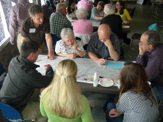
One of the best models for how to do this is the community “charrette,” which is a multi-day open public process with multiple feedback loops for the public to interact with a variety of professionals with complementary expertise in planning, urban design, architecture, transportation, law, public safety, real estate economics, and public administration.[ref]More information on charrettes is available from the National Charrette Institute. For a more detailed look at the charrette process, see “An Introduction to Charrettes,” by Bill Lennertz, Aarin Lutzenhiser, and Tamara Failor (Planning Commissioners Journal, Summer 2008).[/ref] The range of professionals involved is typically determined based on the specific context and issues likely to be addressed during the community planning process.
The idea is to get everyone in the same room together to work through differences and arrive at a common vision.
Charrette photos courtesy of Ferrell Madden.
The idea is to get everyone in the same room together to work through differences and arrive at a common vision. This is a highly structured and visual process.
This is a highly structured and visual process, where drawings are made, discussed, redrawn, and debated openly in public over several days.
There are other models for public engagement, but they are all based on the principles that make charrettes effective, that is, wide stakeholder involvement; several feedback loops to gather and respond to public input; and in-depth interaction between an interdisciplinary team of professionals, public officials, and citizens. The professionals learn about the community and the community learns about key planning principles that become the basis for creating walkable, mixed-use places and provide the foundation for a good form-based code.
A charrette process typically culminates in a place-specific “vision plan,” which is a heavily illustrated physical plan showing the results of the discussions held at the charrette, embodying the best thinking of the involved professionals and public working together. It is much more than a policy document, showing very specifically how the public realm should be shaped, as well as the nature, location, and character of public spaces and the relationships between buildings and the streets they frame.
Relationship to the Comprehensive Plan
The vision plan that emerges from a charrette or similar public engagement process should be made part of the comprehensive plan (also called the general plan or master plan depending on the state) for the community. Comprehensive plans in the past have typically emphasized elaborate statements of policy supported by extensive data and map information, without showing the proposed physical form of the community. While this information may be useful background, it is not nearly as important as the graphic formulation of the community’s vision of itself as a physical place.
C is for Comp plan. Illustration by Paul Hoffman for PlannersWeb.
A revolution is occurring in comprehensive planning, in which plans are increasingly being done as “form plans” that not only express policies and goals for the future, but also describe specific physical forms that the community wishes to embrace at different scales, from the region to the municipality, to the street, block, and even lot.
In other words, the comprehensive plan is becoming more visual and showing what kind of place the community desires to be and how it should look. This is important in underpinning the development of a FBC, which translates the form plan into form-based regulations.
Comprehensive plans can help determine areas where greater walkability is desired and vehicular traffic needs to be slowed, as well as areas where more suburban, car-oriented styles of development make sense. Form planning thus identifies which areas of the community should have traditional walkable urban form and what that form should be, while also identifying areas suitable for suburban types of development.
Comprehensive plans can also identify different types of areas, where the primary goal for future growth and development could be characterized as “transformation,” “enhancement,” or “maintenance of existing character.” Most of a municipality would fall into one of these three categories.
Illustration by Paul Hoffman for PlannersWeb.
Transformation areas are places like abandoned industrial sites, underperforming shopping malls, aging auto-oriented corridors, or vacant office buildings. These areas are suitable for FBCs designed to completely change their existing character.
Enhancement areas are places that are already in fairly good condition, but would benefit from improvements to streetscapes, renovation of existing buildings, and construction of infill buildings to improve the public realm. FBCs in these areas would build on the strengths of the existing fabric, repair the areas that detract from it, and fill gaps in the fabric of buildings.
Maintenance areas are those urbanized neighborhoods that are in good shape physically and are economically stable, often appreciating in value. FBCs in these areas are typically designed to maintain the strengths of these areas and ensure that any new development fits with the existing form and character. In stable, healthy residential neighborhoods, FBCs may not be necessary if the existing zoning seems to be working.
In suburban areas that already have a “sprawl” character, FBCs are not usually appropriate, unless the community decides to engage in “sprawl repair.”
In suburban areas that already have a “sprawl” character, FBCs are not usually appropriate, unless the community decides to engage in “sprawl repair,” for example, converting a moribund strip shopping area into a new mixed-use pedestrian-oriented town center. Where the community goal is to maintain existing suburban development patterns, the suburban-style zoning that created these areas is usually a suitable tool for maintaining them.
Undeveloped areas of forest, farmland, and highly constrained land (such as wetlands, steep slopes, and areas with poor soil conditions) are not generally regulated by a FBC if the community’s intent is to preserve them in their forested, agricultural, or natural condition. The comprehensive plan should indicate if this is the goal for these areas and what preservation tools might be used to accomplish this goal.
Illustration by Paul Hoffman for PlannersWeb.
Where forest or farmland sits at the edge of a developed area and is suitable for development expansion, the comprehensive plan can be a good tool for determining what kind of future development, if any, is envisioned. If the development would be walkable and urban in nature, then a FBC would be an appropriate tool to deploy.
FBCs may also be especially helpful in areas that are planned to be locations for new transit stations or improved transit service, where “transit-oriented development” can add density and walkable mixed use to areas that are walking distance to high-frequency mass transit. These areas should also be identified in the comprehensive planning process. Editor’s Note: For an introduction to transit-oriented development, see Hannah Twaddell’s “The ABCs of TOD: Transit-Oriented Development.”
Misconception #6 — Form-Based Codes are a Panacea for all Land Use Problems
Form-based codes are not a panacea for every problem — they are a tool for creating good urban form for walkable communities.
They should be crafted in a way that takes account of other issues of community concern, such as housing affordability, economic vitality, social justice, traffic management, climate resilience, energy conservation, obesity, stormwater management, and so on.
These concerns can be built into a form-based code, just as they can be integrated into other forms of land use regulation, but there must be a conscious effort to do this, and adopting a form-based code will not, by itself, solve these other problems. However, by encouraging compact mixed-use walkable development, form-based codes often have salutary effects by reducing energy consumption and dependence on the automobile.
Developing a Form-Based Code
As we’ve noted, the process of developing a form-based code often begins with a community charrette process. The first step of a charrette typically involves the documentation and analysis of existing conditions, identifying what is valued and worthy of preservation, and what needs to change. This step may also involve some kind of visual preference survey[ref]For more on visual preference surveys, see “Understanding & Making Use of People’s Visual Preferences,” by Anton C. Nelessen & James Constantine (Planning Commissioners Journal, March/April 1993).[/ref] in which the public weighs in on the types of buildings and streetscapes it would like to see. Community involvement with this is vital and the charrette process can provide an excellent means for getting broad community input.
From the analysis of existing conditions and the physical design process of the charrette, the charrette team, in collaboration with the community, develops a “vision plan” or concept plan for the area that will be regulated by a FBC.
The vision plan should also take account of current — and projected future — market conditions and infrastructure plans and constraints, so that it is not just a fantasy plan, but is grounded in economic, physical, and fiscal reality.
The vision plan usually involves an “illustrative plan view” diagram (looking at the site from above) as well as eye-level renderings of what a desirable streetscape and buildings would look like, along with computer simulated “before and after” images to assist the community in understanding potential change over time.
The vision plan should also take account of current — and projected future — market conditions and infrastructure plans and constraints, so that it is not just a fantasy plan, but is grounded in economic, physical, and fiscal reality.
Once there is broad agreement on the vision plan, it can be translated into a form-based code using the basic elements described in the previous part of this article (i.e., a detailed regulating plan, standards for buildings and building frontages, public space standards, street cross-sections, and administrative procedures).
Form-based codes make extensive use of graphic communication tools, such as diagrams, photo illustrations of intent, building frontage elevations, cross-sections, and plan view drawings. While the graphics in a vision plan are a good starting point, in order for them to be effective as a legal code, they must be drawn in a very precise manner, showing measurements with explanatory captions that make the meaning of any graphics very clear. This is where the skills of an attorney well-versed in urban design can be very helpful, as the kind of vague language that may be perfectly acceptable in a plan (or design guidelines) will not stand up to legal scrutiny when it is in a regulatory document, such as a form-based code. Therefore, there must be very clear graphics and graphic explanation, as well as clear text and definitions.
Misconception #7 — Form-Based Codes are Too Expensive
Because form-based codes are tailored and customized to specific neighborhoods, corridors, and downtowns, they require considerable up-front investment in crafting a shared public vision, illustrating it graphically, and writing it into law.
Viewed in isolation, this can seem expensive. However, keep in mind the considerable expense and time most cities and towns incur administering the development review process, negotiating “special use” projects, adjudicating land use disputes because of dysfunctional zoning codes, and writing voluminous but vague comprehensive planning documents.
In contrast FBCs should be less expensive in the long run because everyone knows what is expected, and administration and enforcement are more efficient.
Once a FBC has been drafted, discussed, and thoroughly vetted with various interested constituencies, it is adopted into law by the legislative body of the municipality. It then becomes part of the overall municipal code, usually as a zoning amendment, but it may also amend other sections of the code, such as street specifications and subdivision regulations.
Misconception #8 — Form-Based Codes are Not Enforceable
Some “so-called” form-based codes are really just unenforceable design guidelines. A true form-based code is adopted as law under applicable state law provisions and is fully enforceable.
FBCs are administered through the normal zoning administrative process, but most approvals are done “by right” because the FBC contains enough specificity to reduce the amount of discretion that sends many development approvals through convoluted processes involving planning commissions, zoning appeals boards, design review committees, and city councils.
Adopting a FBC requires extra time up-front by a planning commission, but results in a much smaller workload for the commission over time, as more applications are approved in a routine fashion administratively.
Is a Form-Based Code Right for My Community?
A form-based code is not a one-size-fits-all document. … It has to be adapted to local conditions and priorities [and] be rooted in the community’s values and objectives.
A form-based code is not a one-size-fits-all document. It must emerge from a planning and public participation process that includes the people who will be using it or will be affected by it. Therefore, it has to be adapted to local conditions and priorities. It must be rooted in the community’s values and objectives as articulated through an open public process guided by experienced practitioners with expertise in a variety of disciplines.
As we’ve noted, form-based codes are not a panacea and are not appropriate everywhere. They are written differently depending upon the goals of the community, the design intention of the vision plan, and the existing conditions and projected future changes in population, economy, and transportation. Key variables include whether an area is economically booming, depressed, or stable; whether or not robust public transportation is available; and whether the location is urban, suburban, or rural. Since the FBC is a “place-based” planning and zoning tool, different approaches may apply in different locations.
We’ve stressed that one of the key reasons to have a form-based code is to create or strengthen a walkable place with an attractive public realm — a place where people will want to congregate because it feels like an “outdoor room.” For this reason FBCs can also spur economic development, breathing life into downtowns or specific neighborhoods.
The best way to determine whether or not a FBC is appropriate for your community is for you to learn as much as possible about FBCs and to engage the community about its own vision for the future. More information on form-based codes, including descriptions of upcoming courses and downloadable webinars is available at the Form-Based Code Institute’s website and Facebook page. An excellent publication that introduces form-based codes to communities is also available for free download (pdf file).
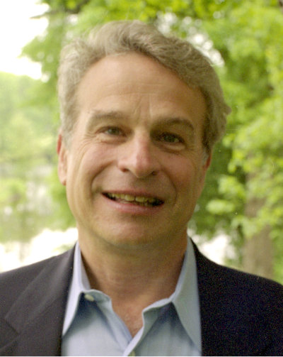
Mary Madden, AICP, has nearly 20 years of experience in the fields of urban planning and design, community development, and historic preservation at the federal, state, and local levels. Her recent projects have been completed in a variety of diverse locales, including: Peoria, Illinois; Memphis, Tennessee; Farmers Branch, Texas; Prince George’s County, Maryland; Marquette, Michigan; Arlington, Virginia; and Fayetteville, Arkansas.
Ms. Madden frequently speaks and writes on the topics of urban design and form-based codes. She co-authored “Place Making with Form-Based Codes” for the September 2006 issue of Urban Land magazine, and was a contributor to the National Charrette Institute’s 2008 Best Practices Report, and to the APA/CNU publication Codifying New Urbanism: How to Reform Municipal Land Development Regulations.
Before joining Ferrell Madden LLC in 2001, Ms. Madden served in several positions at the U.S. Department of Housing and Urban Development. Earlier in her career, she was the co-director of the Mayors’ Institute on City Design. She currently serves as Chair of the Board of the Form-Based Codes Institute.
Joel S. Russell, a lawyer and planner, is the Executive Director of the Form-Based Codes Institute. Prior to assuming that position in early 2014, he was the Principal of Joel Russell Associates, serving as a community planning consultant and land use attorney to cities, towns, counties, and landowners for over 25 years. His national practice specialized in smart growth, traditional urbanism, form-based codes, and rural land preservation.
Joel has written and revised dozens of zoning codes, both conventional and form-based, published numerous articles, spoken at conferences, and co-authored reports, including “Codifying New Urbanism” for the Congress for the New Urbanism and the American Planning Association. He is a member of the Bar in New York, Massachusetts, and Connecticut, and received his Bachelors degree from Harvard and J.D. and Masters Degree in Urban Affairs from Boston University.
 A charrette process typically culminates in a place-specific “vision plan,” which is a heavily illustrated physical plan showing the results of the discussions held at the charrette, embodying the best thinking of the involved professionals and public working together. It is much more than a policy document, showing very specifically how the public realm should be shaped, as well as the nature, location, and character of public spaces and the relationships between buildings and the streets they frame.


 This step may also involve some kind of visual preference survey[ref]For more on visual preference surveys, see “Understanding & Making Use of People’s Visual Preferences,” by Anton C. Nelessen & James Constantine (Planning Commissioners Journal, March/April 1993).[/ref] in which the public weighs in on the types of buildings and streetscapes it would like to see. Community involvement with this is vital and the charrette process can provide an excellent means for getting broad community input.
Because form-based codes are tailored and customized to specific neighborhoods, corridors, and downtowns, they require considerable up-front investment in crafting a shared public vision, illustrating it graphically, and writing it into law.
Mary Madden, AICP, has nearly 20 years of experience in the fields of urban planning and design, community development, and historic preservation at the federal, state, and local levels. Her recent projects have been completed in a variety of diverse locales, including: Peoria, Illinois; Memphis, Tennessee; Farmers Branch, Texas; Prince George’s County, Maryland; Marquette, Michigan; Arlington, Virginia; and Fayetteville, Arkansas.

Joel S. Russell, a lawyer and planner, is the Executive Director of the Form-Based Codes Institute. Prior to assuming that position in early 2014, he was the Principal of Joel Russell Associates, serving as a community planning consultant and land use attorney to cities, towns, counties, and landowners for over 25 years. His national practice specialized in smart growth, traditional urbanism, form-based codes, and rural land preservation.